This involved first riding bicycles from Badwater to the Whitney Portal trailhead.
Because two smaller ranges had to be crossed, this represented over 15,000
vertical feet and about 150 miles. Ron dropped out of the bike leg early to
save energy for the climb. With the bike leg over half complete, Terry collapsed
from dehydration and was hospitalized. Mitch made it all the way to Whitney Portal.
Ron and Mitch then continued on to climb the East Face.
Present Day
Terry has wanted to climb the East Face ever since. He had climbed the
Mountaineers route in bad weather in an earlier East Face attempt
even before the "lowest to highest" attempt. So this year he began recruiting
early and put together a team that included me, Mitch, Ron, Chip Carpp, and
Brian Dodge. Brian flaked out at the last minute, so Terry brought along his
21 year old son, Eddie.
The six of us met at Sea-Tac Airport at 5 PM on Friday the 19th.
We flew into the Ontario Airport, about 40 miles east of LA, rented a minivan,
and were on the road by 9 PM. A short 10 mile hop on I-10 took us to the San
Bernadino Freeway (I-15). We took I-15 Northeast for 30 miles to US Hwy 395
which we took for another 170 miles North to Lone Pine.
Lone Pine
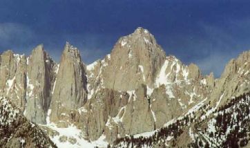
Lone Pine sits in the Owens Valley immediately below Mount Whitney. The valley
floor is at about 3000 feet and is bordered by a small mountain range to the
East, and the spectacular Eastern Sierra to the West. The climate is arid and
most of the vegetation is sagebrush. I remember getting out of the van and
thinking to myself "something smells familiar", then saying "Oh yeah... sage...
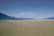
like in my spice rack!" Just South of Lone Pine we saw a huge dry lake bed,
the size of Lake Washington. It used to be Owens Lake.
Owens Dry Lake
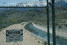 Water Heading to LA
The Owens Valley has a unique place in the history of Los Angeles. In the 1920's the famous LA city engineer Mulholland constructed an aqueduct from the Owens Valley to Los Angeles. At that time, Owens Lake was a robust resource that contributed to the local agriculture and recreation. But it was a doomed lake. LA sucked it dry and turned the area into a dust bowl. To this day, people in the Owens Dry Lake area suffer health problems from wind-whipped dust containing toxic alkali and mining residue from the dry lake bed. LA's quest for water has since extended over 100 miles farther North to Mono Lake, but that's another story.
Another attraction near Lone Pine is the Alabama Hills, the filming location of many Hollywood westerns.
We arrived in Lone Pine close to 1 AM and checked into our hotel. In the morning,
we packed our gear, had a big breakfast, and headed up the West side of the
valley to Whitney Portal.
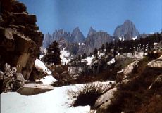
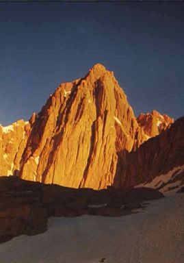
The Approach
El Niño did us no favors on Mount Whitney this year. The snow pack was three
times normal, and the normally snow-free East Face had numerous snow patches
on the technical rock routes. There is a "tourist route" up Whitney that
consists of a 10.7 mile trail that is gentle enough for pack animals. Because
of this easy ascent route, the mountain sees over 1000 summiteers a year.
Due in part to the heavy snow, we saw only a few parties all weekend.
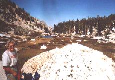
 The trailhead is at 8300 feet and we planned to camp at Iceberg Lake at 12,500
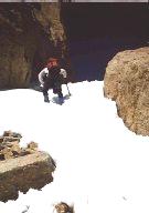
feet. The first obstacle was the Ebersbacher Ledges. It was easy scrambling,
but with our huge packs, it was important to maintain sure footing. Since
Eddie was not used to such exposure, the Ledges were a bit intimidating
for him. By the time we reached Lower Boy Scout Lake at 10,000 feet, Eddie
was ready to give up. Terry decided that they
would bow out, stay the at the lake, and wait for our next-day return.
Mitch, Ron, Chip, and I continued up.
The trailhead is at 8300 feet and we planned to camp at Iceberg Lake at 12,500
feet. The first obstacle was the Ebersbacher Ledges. It was easy scrambling,
but with our huge packs, it was important to maintain sure footing. Since
Eddie was not used to such exposure, the Ledges were a bit intimidating
for him. By the time we reached Lower Boy Scout Lake at 10,000 feet, Eddie
was ready to give up. Terry decided that they
would bow out, stay the at the lake, and wait for our next-day return.
Mitch, Ron, Chip, and I continued up.
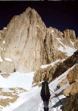
 The trail was snow-free up to the lake, but completely snowed-in above. One
of the side effects of planning for the snow was the extra gear we had to haul.
We carried complete snow, ice, and rock equipment. We decided to camp at a point
just under 12,000 feet since we were all getting pretty pooped from the heavy
packs. It also seemed that Ron was having some altitude problems.
The trail was snow-free up to the lake, but completely snowed-in above. One
of the side effects of planning for the snow was the extra gear we had to haul.
We carried complete snow, ice, and rock equipment. We decided to camp at a point
just under 12,000 feet since we were all getting pretty pooped from the heavy
packs. It also seemed that Ron was having some altitude problems.
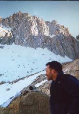
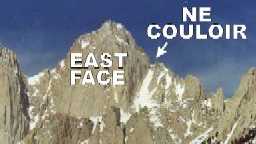 Terry and Ron are the top rock climbers in the group and we were relying on
them to lead the crux pitches on the East Face. Without Terry, and with Ron
not feeling tip-top, and with the route being in questionable condition, we
decided to do the less technical Mountaineers route. This route consists of
the steep 1400 foot Northeast Couloir, and an airy traverse to the summit
plateau.
Terry and Ron are the top rock climbers in the group and we were relying on
them to lead the crux pitches on the East Face. Without Terry, and with Ron
not feeling tip-top, and with the route being in questionable condition, we
decided to do the less technical Mountaineers route. This route consists of
the steep 1400 foot Northeast Couloir, and an airy traverse to the summit
plateau.
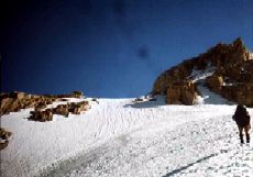
The Climb
 We got up Sunday morning, strapped on our crampons, left the rock gear behind,
took one rope in case it was needed, and headed up. Ron hadn't eaten much
and was still suffering from the altitude. He had to stop two-thirds of the
way up the couloir, found a ledge, puked, and waited for our return.
We got up Sunday morning, strapped on our crampons, left the rock gear behind,
took one rope in case it was needed, and headed up. Ron hadn't eaten much
and was still suffering from the altitude. He had to stop two-thirds of the
way up the couloir, found a ledge, puked, and waited for our return.
When the three of us reached the top of the couloir, we saw our remaining
objective. It was a 300 to 400 foot traverse of the North Face, with the first
fourth of it being quite steep and exposed. We considered roping up and
belaying the initial section, but decided that ice axes and careful
cramponing in the existing steps would be adequate security.
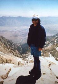
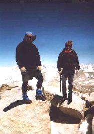
Following the traverse, we removed our crampons and walked up a gentle slope
to join the Whitney Trail near the summit. Still standing in good repair is
the Smithsonian Shelter, built in 1904. We were alone on the summit under a
clear blue sky.
The descent went fairly quickly and included a rare 1000 foot glissade
of the Northeast Couloir. We met up with Terry and Eddie and were back in Lone
Pine by 6 PM.
The Return
We checked back into our hotel in Lone Pine, went out to dinner, and hit
the sack early. The next morning, we got up, re-packed, went out for
breakfast, did a little tourista shopping, checked out, and headed back
to the Smell A area.
We pulled into Ontario at about 2 PM. Our flight out wasn't until 9 PM. We planned the late flight in case we had to spend Sunday night on the mountain. Since we had a lot of time to kill, Mitch met up with his brother who lives in the area, and rest of us headed for the beach.
On most expeditions with these guys, the first objective is to climb a mountain, and the second objective is to go to a Hard Rock Cafe. This trip was no exception. We wound up spending most of the late afternoon at the Hard Rock Cafe in Newport Beach, then drove back to Ontario and flew home.